When Mother Nature brings an unexpected challenge to your project or operation, drilling alone may be cost-prohibitive and ineffective. Geophysical studies can quickly develop large visuals of subsurface information, allowing further drilling operations to be highly cost-effective and time efficient.
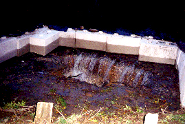
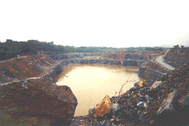
After the passing of Hurricane Floyd, a quarry in southeastern Pennsylvania observed a large influx of water entering their quarry pit. During an onsite inspection several sinkhole or dissolution features were observed along geologic strike towards a shallow creek. Probing of the creek in a flat bottom boat with a 30-foot pole revealed a large sinkhole had developed in the bottom of the creek. Based upon the onsite inspection, GeoSonics/Vibra-Tech recommended conducting an automated vertical electrical resistivity sounding scan to map the potential conduit supplying the quarry with water. The distance from the creek to the quarry was approximately 460 meters. The resistivity study consisted of six parallel lines, 140 meters in length. The conduit was identified within two days, and subsequent drilling was organized. Water and water-saturated clay zones are typically highly conductive and, therefore, have low resistivities. The low resistivity areas on the cross-sections are denoted by dark to light purple colors. The large dark purple anomalies caused the greatest concern because they occurred along the projected geologic strike of a clay seam and the observed dissolution features. Subsequent drilling then occurred at the field location of the observed anomaly. The driller’s log indicated a wet clay material was overlaying a 1-meter thick water zone with significant flow. This zone was located above a hard rock layer approximately 18 meters beneath the surface at this location. This feature was expected to be the potential pathway for flowing water into the quarry. The identification of the initial sinkhole in the bottom of the creek, and its subsequent grouting, yielded the largest net reduction of water flowing into the pit. Through the use of resistivity profiling, the potential conduits for inflowing water were identified, allowing for the creation of a grout curtain to yield further reductions of water into the pit.